|
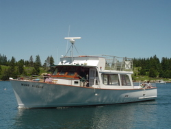
Mail BoatA visit to Isle au Haut starts in Stonington at
the Isle au Haut Company on the waterfront. There, at what used
to be a sardine cannery, you board the passenger ferry, also known
as the mailboat. It's a substantial vessel, larger than the many
lobster boats moored in the harbor, with about equal inside and
outside seating.
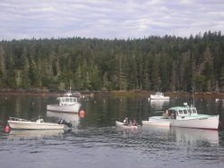
Lobster BoatsThe departure is usually on time. The crew throw
off the dock lines and the diesel engine revs up. If there's other
boat traffic about, the progress is cautious as it proceeds across
the Deer Island Thorofare to follow a well traveled course to the
High Island. Many smaller islands and ledges are visible along this
route. One significant island ahead and to the west has the cliffs
and tall mast of a large granite quarry. This is a large operation
which ships big blocks of granite to cutting facilities elsewhere.
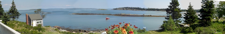
Near the halfway point, the ferry crosses Merchant's Row, an inland waterway
between Camden and Bar Harbor. Many pleasure craft follow this route in
summer as it provides good room for sailing yet gives some shelter from
the open ocean. On the port bow is Merchants Island and ahead in the distance
is Kimball's Island, both places barely occupied. Then, more detail of
Isle au Haut becomes visible.
The church spire is one of the first signs of the town. Drawing closer,
the boat may stop at Point Lookout, a summer colony on the Island. From
there, the boat enters the Isle au Haut Thorofare, a channel between that
Island and Kimball's Island. The passage here is narrow and shallow. At
very low tides, the boat may be forced to go around Kimball's Island for
deeper water.
From the Thorofare, the houses of the town are quite visible with a few
piers on the shore. One of the larger piers is the fuel dock at the Island
Store where the fuel barge pumps gasoline and heating oil ashore. The
boat then maneuvers into the Town Dock where the crew tie up to a float.
There's always activity at the Town Dock with the arrival or departure
of the boat. Passengers are unloaded first, then freight is unloaded and
loaded.
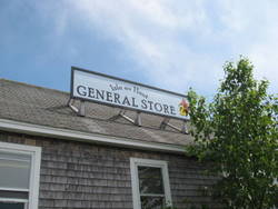
Island StoreWhen
your arrival is expected your hosts will be waiting on the dock.
If not, walk off the dock and up the incline passing the Power Company
building on your left. Ahead are a couple fine, older homes above
the road. The dock lane soon merges with "Main Street"
and take a left through town. A tiny post office is just ahead.
From there, the Island Store is visible on the waterfront. It's
your only chance to buy some food or drink. A picnic table outside
offers a place to sit and eat.
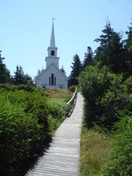
Island ChurchAfter
the store, there's a boardwalk on the right which climbs the hill
to the church. It's a beautiful structure, always open and worth
a side trip if you can manage it. A large chandelier with 13 lamps
once burned whale oil for lighting. On the east end, a fine stained
glass window of the Good Shepherd has a memorial to a Turner woman
who was important in founding the church.
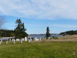
Turner CemeteryBeyond the church and by the road is an open
field with a good view of the Thorofare. At the far edge of the
field is the Turner Cemetery. Reminders of the nautical setting
and the hazards of the sea are common on the markers. Then just
uphill is the Town Hall and library in a sturdy stone building flanked
by nice summer homes. Another short distance and the fire station
is on the right with the new power station behind it. Although the
Island power comes from Stonington by cable, a generator on the
Island serves in emergencies.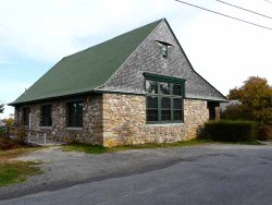
Town Hall
Next, on the left, is the one room schoolhouse with eight grades
available. Usually, not all eight grades are used and the Island
school population is a concern. Attempts to attract young families
to the Island haven't succeeded well.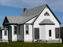
School House
Ascending a hill, the road passes the last half-dozen homes in
the village. Then the road continues through forest for another
mile or so, passing only a couple places and then descending toward
the east side of the Island. On the left are two access roads to
Rich's Point and Rich's Cove on the northeast corner of the Island.
Now the road heads south for several miles with scattered houses
and few views of the sea. 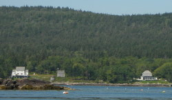
Turner Cove and The Inn
The Inn at Isle au Haut and Turner Cove are on this part of the Island.
Little Red was once the east side schoolhouse and now is part of
the Turner property. Walking down that lane gives you a broad vista
from the east side which includes Mt. Desert Island, Swans Island
and close by, York Island. The latter protects Turner Cove from
the open ocean beyond it. Turner Cove has been in continuous ownership
of family members for 170 years or more although the present owners
are distant cousins of the original settlers.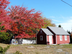
Little Red
Settlement is sparse beyond Turner Cove. The paved road turns to
dirt in another mile. After about two miles of woodsy dirt road,
there's more pavement. On the left in the paved section is a parking
area, probably unmarked, with a short trail beyond leading to the
shore. This piece of coast, privately owned, has a broad boulder
beach called "Boom Beach" from the sound of rocks rolling
on lefge below during storms. A prominent ledge, just offshore,
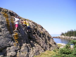
is Elephant Rock and seagulls flock to its back.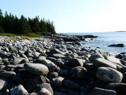
Boom Beach
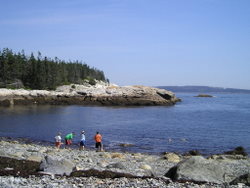
Looking south from Boom Beach is the small island of Eastern Ear, just
off Eastern Head. Facing east we can see two bare Islands, Black Cow and
White Cow. Among the rocks by our feet high on the shore are beach peas
which are quite edible when they ripen in mid to late summer.
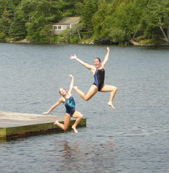
Long PondContinuing south on the road, we pass a small beach at the foot of Long
Pond. This
freshwater pond is narrow and about one mile long. Its depth goes
well below sea level. Had the ledges near the foot of the pond been
lower, the pond would have been connected to the ocean. As it is,
it's a great place to swim in the summer in an area where the sea
is so cold.
Another half mile brings us to Head Harbor with its settlement
of about a dozen homes.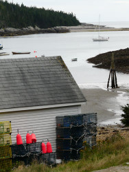
Head Harbor On the east side of Head Harbor is a dirt road
which leads to National Park property. This piece of the Park called
Eastern Head has high granite shores facing the open ocean. A deep
chasm splits the shore at one place called "Thunder Gulch."
When the waves are rolling, Thunder Gulch makes noise to rival the
much better known Thunder Hole near Bar Harbor. It is rare to find
other people there when you visit. 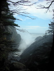 ` `
Thunder Gulch
Beyond Head Harbor, the road is not paved as we cross the Island to the
east side once more. Not far along this road is a sign showing the National
Park boundary. The Park retains their land on the Island as a wilderness
area with few improvements. About midway to the east side is the entrance
to the Goat Trail, a rugged shore path along the sea. Staying on the road,
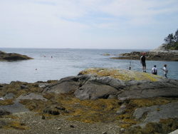
the sea is encountered again at Duck Harbor.
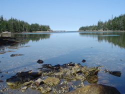
Duck HarborA service road (no vehicles allowed) leads along
the south shore of beautiful, tranquil Duck Harbor, past a small
Park campground. In summer, the ferry brings visitors to come ashore
in Duck Harbor for day visits. On the left is a steep trail up Duck
Harbor Mountain. This leads to the best coastal views on the Island
with Penobscot Bay at your feet, Vinylhaven in the middle distance
and the hills of Camden beyond. Staying on the service road brings
us to Deep Cove, a pretty stone beach between small granite cliffs.
Deep CoveBeyond Deep Cove, a trail leads to the Cliffs, spectacular,
hundred foot high shores along the open ocean. If you're hardy,
catch your breath at this sight and continue on the shore trail
around Western Head, as nice a coastal hike as there is in Maine.
That brings us back to Duck Harbor. A short hike along the north
side of Duck Harbor leads to a high, rocky headland called Eben's
Head. It's a perfect spot for a picnic as lobster boats circle below,
pulling traps.
Eben's HeadHeading north on the east side of the Island,
the road is woodsy, touching the shore only at a couple points.
The road eventually exits Park land close to another small settlement
on Moore's Harbor. Another trail on the northern shore of Moore's
Harbor leads to a very sheltered cove called Seal Trap. This is
private land but the owner share this gem with the public, even
maintaining the trail. On the far side of Seal Trap is a path to
Trial Point with a good chance of sighting eagles overhead.
Seal TrapHeading north and back towards the village again,
the next chance to glimpse the sea is by a lane leading to the lighthouse.
This structure is owned by the Town although the Coast Guard maintains
the light. It's thought by some that it's the picture-perfect light
on the coast. The adjacent house was operated as a B&B for some
years. The lighthouse property was in the Greenlaw family for some
years. Now, Linda Greenlaw of nautical writing fame, lives in a
house overlooking the lighthouse from a distance.
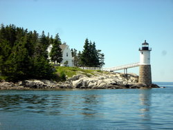
LighthouseThe lighthouse is at the southern end of the Isle
au Haut Thorofare. It is not far from it to the village again. Along
the way you may find a chocolate shop and a gift shop among the
scattered buildings. Then you'll see the National Park buildings
with a rest room and water. From that, it's an easy walk along paved
road again down the hill to the Town Dock.
For the really adventurous, the forest of the interior of the Island
has several trails and a few high points with good views. Then, down at
sea level, sea kayakers may circumnavigate the Island in good weather.
Beyond, there are a number of uninhabited islands to be explored by island
hoppers. But that's another story.
|